HOME > Attractions > Stirling Range
Stirling Range - Mountains of Mystery
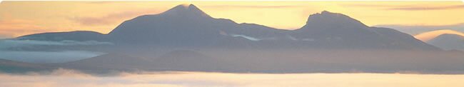
One of Western Australia's few mountain wildernesses, the Stirling Range National Park is a place of contrasts. Blessed with rugged mountain peaks rising to 1095 metres above sea level at Bluff Knoll (the highest peak in south-western Australia), and fragile wildflowers, the Stirling Ranges span 65 kilometres from east to west.
The Aboriginal name Koi Kyeunu-ruff ("place of ever moving about fog and mist") is an appropriate name indeed for the Stirlings. A wildflower and plant reserve of international significance, the Stirlings springtime wildflower display (August to November) is justifiably famous. Blessed with over 1500 plant species, rare orchids, mountain bells and banksias abound. 148 bird species - 90 of which breed in the park - and 19 species of native mammals call the park home.
A bushwalking, sightseeing and rock climbing mecca, these alluring blue mountains are accessed through historic Kendenup or the Porongurups via Chester Pass Road. Subject to unpredictable weather changes - they are WA's only site of intermittent snow falls each winter - the mountains should be respected when exploring the diverse terrain. Please take appropriate clothing, wear sunscreen and a hat and take sufficient water. Walkers who engage in longer hikes are advised to make note of this information in the book provided at the Ranger's Station at the corner of Bluff Knoll/Chester Pass Road or at Moingup Spring.
Walks in the Stirling Range National Park
Survival Tips - Park Pass required; weather can change quickly, so wear appropriate clothing, footwear and sunscreen; carry water. Toolbrunup Park - Approximate elevation 1052m. A popular hike which entails some loose rock, scrambling conditions in places and is considered steep and challenging for the average person. The approximate return time is 3 hours. It is recommended to follow the marker posts and not to stray on side tracks.
Mount Hassel - Approximate elevation 847m. A relatively short hike with a return time of about 21/2 hours. The trail is clear but one may stray on dead-end tracks, so be observant. A popular hike affording wonderful views. Not considered difficult.
Bluff Knoll - Approximate elevation 1094m. Certainly the most popular walk with return time of about 31/2 hours. Trail is well marked.
TolyuberlupPeak - Approximate elevation 783m. Rugged in appearance but popular, with a return time of about 21/2 hours. Closer to the summit there are a few option tracks available and some scrambling is required.
Mount Trio - Approximate elevation 856m. A feature worth the effort with one stretch being difficult and steep in spots . From the saddle you have a choice between the East Peak or North Peak, with the return time being about 21/2 hours.
MountMagog - Approximate elevation 856m. Considered a longer walk with the trail not distinct in places. The approximate return time is 51/2 hours. The hike entails a north and south peak.
|